
Related News
- 00
0000-00
How order volume affects private label equipment production costs - 00
0000-00
Volvo Group Plans Dedicated Mining Entity for Equipment and Autonomous Solutions - 00
0000-00
How much does a 3D grader guidance system cost fully installed? - 00
0000-00
How to verify capacity before sourcing equipment from manufacturers - 00
0000-00
When to choose LGP dozers for infrastructure site preparation
Which Accuracy Metrics Matter in Autonomous Construction Control Software?
Autonomous construction control software is often introduced with one attractive number: a claimed positioning accuracy. That number may be useful, but it is rarely enough to predict field performance. A machine can know its position very precisely in ideal satellite conditions and still leave an inconsistent grade, react too late to a design transition, or lose confidence when the site becomes obstructed, dusty, wet, or electrically noisy.
For earthmoving operations, accuracy is not a single specification. It is a chain that begins with the design model, passes through GNSS, total station, laser, inertial, and machine sensors, then reaches the hydraulic control system and the cutting edge, bucket teeth, blade, or attachment. The result that matters is whether the machine repeatedly produces work within the project’s required tolerance while remaining predictable when sensor quality deteriorates.
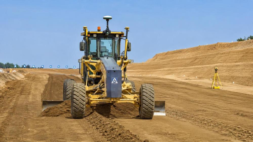
That distinction matters across crawler excavators, motor graders, bulldozers, wheel loaders, and compact skid steer loaders. A grader finishing a pavement subgrade has different accuracy priorities from an excavator digging a utility trench or a dozer spreading bulk material. Sound software selection therefore starts by translating the required finished condition into measurable control-system behavior.
Start with the finished-work tolerance, not the dashboard claim
The first question is simple but frequently skipped: accuracy of what, measured where, and under which operating conditions? A supplier may describe antenna position, GNSS correction quality, or a sensor’s stated resolution. None automatically equals blade-edge elevation accuracy or excavator bucket-tip accuracy. The physical point that interacts with the ground is what determines rework, material overrun, drainage performance, and acceptance risk.
For grading, the meaningful measure is typically the difference between the as-built surface and the approved digital design at defined locations. For excavation, it may be the bucket tooth position relative to line, grade, offset, and safe exclusion zones. For loading or stockpile work, repeatable placement and avoidance of over-digging may matter more than fine-finish elevation.
A disciplined evaluation separates three layers: design accuracy, machine localization accuracy, and work-result accuracy. If a surface model has incorrect breaklines or an outdated coordinate transformation, excellent automation will reproduce the wrong result with confidence. Model governance, field calibration, and controlled design revisions deserve the same scrutiny as the onboard hardware.
The metrics that reveal real control quality
A practical technical review should require suppliers to define their metrics, reference frames, test methods, and operating assumptions. The following measures address different failure modes; no single one should be used as a proxy for the others.
Absolute accuracy versus repeatability
Absolute accuracy describes closeness to the project coordinate system. It is indispensable where a trench, curb, runway profile, or foundation excavation must match surveyed control. Repeatability describes whether the system behaves consistently when it revisits the same target. The two are related but not identical.
Consider a dozer working a broad site pad. A stable, repeatable control response can reduce the number of corrective passes even if a survey check later identifies a systematic offset requiring recalibration. By contrast, a finish grader cannot tolerate unpredictable elevation scatter simply because its average result looks acceptable. Procurement documents should therefore ask for both bias and spread: not merely an average error, but how much individual measurements vary across a representative work area.
Vertical accuracy at the working tool
Construction sites are three-dimensional, but vertical performance often exposes weaknesses first. GNSS-derived elevation can be more sensitive than plan position to correction quality, satellite geometry, datum handling, and local multipath. A mismatch between the project’s vertical datum and the control software configuration can create a systematic elevation problem that no hydraulic refinement will solve.
The equipment geometry also changes the problem. On a motor grader, blade roll, pitch, articulation, wheel slip, and frame movement influence the final cutting edge. On an excavator, boom, stick, bucket linkage, attachment geometry, and wear points affect bucket-tip calculation. A claimed receiver-level specification should be supplemented by evidence of tool-point validation after calibration and under realistic machine posture.
Sensor fusion quality is more than having multiple sensors
Most capable autonomous construction control software combines more than one source of information. GNSS may provide global positioning; an inertial measurement unit can estimate orientation and short-term motion; encoders or pressure sensors describe machine state; cameras, LiDAR, radar, total stations, and laser references may support particular tasks or constrained environments. The important question is not how long the sensor list is. It is how the system handles disagreement, delay, loss, and recovery.
A robust fusion architecture should time-align its inputs and report confidence in the resulting pose estimate. If a GNSS correction stream drops, the software should make its degraded mode visible rather than silently continue with a level of certainty it no longer has. If an IMU experiences drift during a long outage, the system needs a defined recovery behavior once an external reference returns. Evaluators should ask what actions are permitted in each confidence state: continue automatic control, limit speed, revert to guidance, pause the function, or require operator confirmation.
This matters particularly in hazardous mines, deep cuts, urban corridors, and work zones near large structures. Low-latency communication is valuable for remote supervision, but network availability should not be confused with machine-state accuracy. The local control loop must remain stable even when remote connectivity is intermittent.
Latency becomes visible when the machine starts moving
Static checks can make nearly any system look good. Autonomous control earns its place while the machine is traversing uneven ground, transitioning across breaklines, encountering variable material, or changing direction. End-to-end latency includes sensor measurement, filtering, design-model lookup, control computation, communication over vehicle networks, valve response, and mechanical movement. Each stage may be small, while the total is large enough to create a noticeable lag.
Equally important is jitter: variation in that delay. A predictable delay can often be accounted for in controller design. An inconsistent delay produces unstable corrections, blade hunting, or overshoot at grade changes. For graders and dozers, review control tracking during passes at expected operating speeds, not only at a standstill. For excavators, assess how smoothly the system approaches grade as boom and arm speed change, particularly near the end of a dig cycle.
Machine hydraulics place a practical boundary around software claims. Electro-hydraulic proportional control, valve tuning, cylinder condition, linkage compliance, and payload all influence response. The best autonomous software cannot fully compensate for a poorly maintained implement or an actuator system with inconsistent behavior. Compatibility assessment should include the specific machine configuration, not merely the equipment family name.
Reliability under changing site conditions is an accuracy metric
Site conditions shift throughout the day. Mud can affect track or wheel behavior. Loose material changes blade load. Vibration, dust, rain, glare, and temperature can affect sensors or their protective housings. Antennas can be shadowed, and a bucket-mounted sensor may be exposed to impacts. In these conditions, the relevant measure is not only peak accuracy but the system’s ability to identify when its operating envelope has been exceeded.
A useful acceptance plan defines the expected environment and the checks used to verify performance: surveyed control points, independent as-built observations, machine calibration records, software version tracking, and a process for design-file approval. It should also distinguish operational accuracy from safety functions. Accurate localization supports safer behavior, but collision avoidance, personnel detection, geofencing, and fail-safe machine behavior need their own validation criteria.
Match the evaluation method to the machine and task
For motor graders, a field test should emphasize cross-slope control, elevation tracking, transitions between surfaces, and finish consistency over multiple passes. For bulldozers, cut/fill response, track-slip effects, and productive performance on changing material deserve more attention than a laboratory-like point measurement. Excavator evaluations should include bucket-tip verification at different reaches and attachment positions, along with a clear method for recalibrating after attachment changes or wear-part replacement.
Wheel loaders and skid steer loaders add another dimension: rapid cycle work in crowded or confined areas. Their control systems may need to balance positioning confidence with maneuverability and attachment-specific geometry. A solution that performs well on an open stockpile may require a different sensing approach in a tight urban utility project.
The Global Earth-Mover Dynamics (EMD) follows these distinctions because equipment autonomy sits at the intersection of heavy machine physics and spatial intelligence. A crawler excavator’s hydraulic response, a grader’s surface-control precision, and a bulldozer’s traction behavior do not produce the same accuracy risks. EMD’s Strategic Intelligence Center examines the control logic, communication architecture, and operational conditions behind headline claims, rather than treating autonomy as a uniform feature across all earthmoving equipment.
Questions that should be answered before selection
- At which physical point is accuracy specified: antenna, machine reference point, blade edge, cutting edge, or bucket tooth?
- What coordinate system, geoid model, correction method, and site-control procedure are assumed?
- Is the stated figure an average, a maximum, a confidence-bound result, or a static test outcome?
- How does the system quantify uncertainty and alert the operator or supervisor when confidence falls?
- What are the measured end-to-end latency and control-response characteristics on the intended machine?
- Which calibration steps are required after transport, sensor movement, attachment replacement, software updates, or repairs?
- How are design revisions, as-built records, diagnostics, and audit logs managed across the project team?
The strongest comparison is usually a task-based trial with independent verification, rather than a feature-by-feature scorecard. It should include representative speed, material, terrain, satellite visibility, design geometry, and operator workflow. If the intended project has unusually tight tolerance requirements, acceptance criteria should be agreed before deployment and checked against applicable contract, survey, and local requirements.
Accuracy should be treated as a managed operating capability
The appropriate autonomous construction control software is not necessarily the platform advertising the smallest isolated number. It is the one that can demonstrate a reliable connection between design intent, sensor confidence, machine response, and verified finished work. For high-precision grading, vertical tool-point control and repeatability may lead the decision. For excavation near critical assets, integrity monitoring, coordinate discipline, and graceful degradation may carry more weight. In production earthmoving, control stability and availability can matter as much as peak precision.
Before committing, define the required work tolerance, insist on transparent measurement methods, and test the complete system on the machine and site conditions that will actually be used. That approach turns accuracy from a marketing claim into an operational standard—one that can be monitored, maintained, and trusted as infrastructure work moves toward greater autonomy.